


RAPID CITY, SD – No matter what time of year – Early, early in the morning, you’ll find cafes and restaurants brimming with locals, ranchers and road warriors all enthusiastically talking about the same thing. The weather.

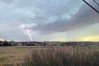
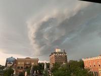
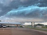
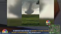
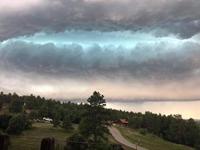
August 8th storm rolling into Rapid City right after it dropped baseball sized hail near Pactola Reservoir
Swapping information, comparing soil moisture, ranting about incorrect forecasts – for many it’s their livelihood, and paying attention is important. There’s an argument to be made that some of the conversations you hear amongst locals and ranchers in this particular region may surprise some who are just passing through. For example, the topic of conversation lately has focused on some unusual stories stemming from the Northern Black Hills.

117648143 3267282370002612 8777162131250145121 N
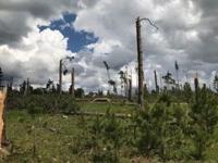
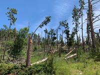
Hillsides flattened, sections of forest unrecognizable, 120 feet trees flying through the air like missiles. Just another tornado in the Black Hills. The idea of swirling columns of powerful winds making the journey up and down literal cliffs seems unreasonable at best. Not to mention multiple times in one year, In the same area. Are we bearing witness to a shift in weather patterns in real time? Matthew Bunkers, a Meteorologist at the National Weather Service in Rapid City, compiled an impressive
spread of datathat suggests that we’re just seeing The Black Hills in its’ natural state – a constant state of ‘unusual’.

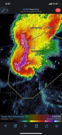
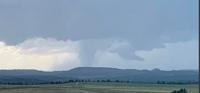
Radar signature from tornadic storm that climbed Terry Peak
“Some of it might be perception, I think people tend to have short term memory, and the most recent thing is the biggest and the baddest,” Bunkers explained. “The 1990’s were notoriously wet and stormy around here, for those that were here at that time and that can recall.” The increasing population and introduction of cellphones has vastly increased our ability to capture these events in real time, as well. Large swaths of forests being cut down may have gone unnoticed 100 years ago. The same can be said of prolific hailstorms that only 20 years ago would have crossed large tracts of uninhabited land.

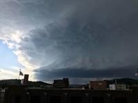
Shelf cloud rolling into Spearfish in Early June – notice the bluish hue indicating that large hail is being kept aloft by powerful updrafts.
The storm in early June of this year is a perfect example, where downtown Rapid City received some hail, but not the gargantuan baseball sized monsters that pummeled north Rapid City. 50 years ago, that would have been open fields. Even without those examples, climate data proves that tornado and hailstorm activity has fluctuated regularly in the Black Hills. Some years Campbell County, Wyoming was the hotspot, other years it’s been Fall River County. Even Rockerville had a well-known tornado that crossed over highway 16 back in the 1960s. That’s all fine and dandy, but that doesn’t explain why tornadoes are jumping up and down literal cliffs in Spearfish canyon, and climbing Terry Peak like a seasoned trail runner. Right now there’s only conjecture as to why tornadoes seem to like the Northwestern Hills this year, but there are some clues. “As the storms approach the Black Hills and move up the terrain of the Black Hills, that may slow them down and sometimes that can favor the development of tornadoes,” Bunkers further explained. Thunderstorms often eject a rush of cool air that spreads out in all directions at the surface. Ironically, this can cut off the warm air supply to thunderstorms, and effectively shut off the storm machine, or at the very least disrupt the strengthening process.

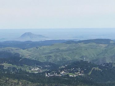
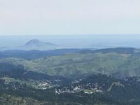
View from Terry Peak, looking down on Lead and Bear Butte in the distance
A storm approaching the Black Hills from Wyoming may find the rising topography and additional friction of hills and trees useful. Cool air trying to rush out of the storm is slowed down, allowing time for the storm to feed off of warm air longer than it originally would have. That could give a storm just enough of a bump to encourage further strengthening. We could also consider the possibility that the friction of the Black hills topography giving extra spin to a supercell thunderstorm, in the same way that water likes to spin as it travels past a rock in a stream. These, of course, are all just theories. (Thankfully), we don’t have a long history of tornadoes in the Northern Black Hills to compile large amounts of data. More tornadoes would allow us to test theories and gather more data. As it stands, we’ll have to make due with the few we do receive from time to time.

Supercell thunderstorm in early July approaching Rapid City
The topography of the Black Hills are known to create their own unique environments, and tornadoes are no different. Look at the differing snow amounts with any given snowstorm during the Winter, it can vary street to street! At the very least, the numerous tornadoes observed jumping up and down cliffs effectively destroys the common myths about lakes and mountains preventing storms from happening.

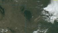
View of the Black Hills 10:42 AM 8-11-2020 from GOES-16 Satellite
Really, the data suggests that the only factor separating storms impacting one location over another is time. Given enough time, strange weather could be knocking on your door next – it pays to be prepared in the Black Hills. One thing is for sure – there’s always going to be weather to talk about when sharing a breakfast table in the Black Hills. Categories:
Local News,
Weather Daily2020
,
Black Hills,
Rapid City,
South Dakota,
Tornadoes,
weatherLooking for more news and information? NewsCenter1 Media Group has you covered go to
NC1.TVtoday for all of your Western South Dakota and Wyoming news today.